
Geographical data
Geographical data Fill the two parts NSOIL and NLAND. In the case of Pavillon-sous-Bois, 1 is for the woods, 2 is for the roads, 3 is for the grass surfaces, 4 is for the houses, 5 is for the gullies, 6 is for the water surfaces and 7 is a class to fill in the missing data. For this last class, choose one of the previous classes according to your land use and copy its parameters. The classes must be sorted by increasing number. The classes have to be the same for land uses and soils. Check that there are as many lines describing the soil classes as there are reported numbers of class. Also check that the highest index in the file “soils.asc” also corresponds to the highest reported number of class. | 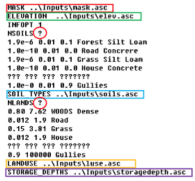 |
As there is no river in the Pavillon-sous-Bois basin, modify the general_input.txt file accordingly.


