
Geographical data on AsimTool platform
Geographical data have been managed in the AsimTool platform to produce Multi-Hydro input:
Land use has been extracted and regrouped in 5 categories
Topography: altitude ranges from 66 m to 72 m
Sewage network in a SWMM format
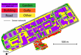 | Loup basin: land use spatial distribution with pixel of size 10 m x 10 m, and sewer network inputted on Multi-Hydro |


